Red River Flooding

Expensive flooding damage becoming a recurring issue
Flooding along the Red River is becoming a recurring and expensive issue. It’s a trend that officials think will continue, and they want the public to be prepared.
“It’s going to happen,” Caddo Sheriff Steve Prator said. “It’s going to be worse. And it’s going to continue to get worse because of the silting in the river. History is showing that.”
Historic flooding in 2015 bears out the financial impact on the community. That year, Caddo Parish received more than $1.8 million in Public Assistance (PA) grants from the Federal Emergency Management Agency (FEMA) for cleanup and rebuilding efforts, according to data provided by Robert Jump, deputy director of the Caddo Sheriff’s Office Department of Homeland Security and Emergency Preparedness.
PA is FEMA’s largest grant program providing funds to assist communities responding to and recovering from major disasters or emergencies declared by the president. The program provides emergency assistance to save lives and protect property and assists with permanently restoring community infrastructure affected by a federally declared incident.
Collectively, seven parishes affected by the 2015 flooding received more than $9.2 million in PA grants. That does not include private losses by individuals who suffered damages in that flood. Our area did not meet the damage thresholds the federal government requires to qualify for the Individual Assistance Grant Program, Jump said. IA grants would be the avenue for private citizens to recoup financially from disaster losses.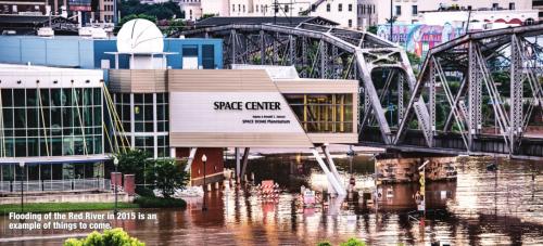
After more significant flooding in 2016, the Caddo Parish Sheriff’s Office commissioned a study of the issues of urban flooding with the Red River in northwest Louisiana. Graduate students from the Bush School of Government and Public Service at Texas A&M University came to study the recurring problems. Their goal was to identify the issues and suggest and evaluate possible solutions.
The study defined urban flooding as “repetitive, costly and systematic impacts on communities, regardless of whether or not these communities are located within a formally designated floodplain or near any body of water.” The study cites excessive rainfall, increased sedimentation, urbanization and inadequate infrastructure as causes for urban flooding.
“Urbanization and the lock and dam system has caused silting in,” Prator said. “Nobody has come up with answers for that. It’s gotten worse each year. It’s going to wind up being more catastrophic.”
Prator said silting had raised the level of the riverbed, but the gauges and maps that forecasters use to predict flooding had not been updated in years. “That’s why the predictions were so terrible,” he said.
Jump said the study confirmed what some already believed about the issues on the Red River.
“It validated what we all believed was happening, especially with 2015,” Jump said. “It was the first time we had had that kind of elevation on the river for some time, at least for the time I have been an emergency manager. We were getting crest elevations and then adjusting the elevations. It’s definitely something that wasn’t being calculated by our models. We were constantly planning on the run.”
While dredging the river is often discussed as a solution, Jump said it comes with its own challenges.
“That’s an expensive process,” he said. “The cost to do that almost outweighs the cost of damage from flooding.
“There is a balance. I just don’t know where it is. Making the river navigable puts money into the economy. That’s important. With the further growth of the city, we have lost some water storage along the river future building plans should take into account.”
The study also faulted the levee system. “All Caddo Levee District-operated levees are either classified as minimally acceptable or unacceptable by USACE standards,” the report said. “A minimally acceptable levee contains one or more unacceptable inspection items that would not prevent the segment/ system from performing as intended during the next flood event. An unacceptable levee contains one or more deficiencies that would prevent the segment/system from performing as intended, or one with a serious deficiency noted in past inspections, but not corrected within two years of inspection.”
Prator added another factor that the study did not address.
“There’s been no talk about doing anything with the jetties,” he said. “We built all these rock jetties to help with the flow through the lock and dam. All that did was create little islands. It worked against us instead of for us.”
The Red River is the fourth longest river in the United States, the report said. Its drainage basin covers 89,970 square miles, beginning in Texas and flowing east between Texas and Oklahoma through Arkansas and into Louisiana. It includes 1,000 navigable miles. The width of the river in Shreveport is 1,360 feet when full, with 183 miles of riverfront. The Red River transports large amounts of sediment downriver. Natural levees and floodplains are created by the river.
According to the National Weather Service’s Advanced Hydrologic Prediction Service, flood stage for the Red River in Shreveport is 30 feet. Moderate flood stage is defined at 31.5 feet, and major flood stage is at 33 feet.
Flooding in 2015 and 2016 generated lots of headlines, but it was not historically the worst flooding on the Red River in Shreveport. In 2015, the river crested at 37.14 feet on June 9, according to the NWS data. That’s 8.76 feet below the highest level on record, 45.9 feet on Aug. 10, 1849. The 2015 flooding ranks 25th on the list of the top 73 flooding events for the Red River in Shreveport.
The river crested at moderate flood stage twice in 2016, the NWS reported. On May 5 that year, it crested at 32.39 feet. Ten days later, on March 15, it crested at 31.79 feet. It crested at 31.39 feet on March 4, 2018.
The Red River crested above flood stage one other time since 2000, at 31.05 feet in March of 2015. The river also has topped 29 feet without reaching flood stage four times since 2000.
Recent flooding has been more impactful as more people are choosing to live, work and play along the Red River, particularly inside the levees. Prator himself owns a house that suffered extensive damage in the 2015 flood. He chose to keep his property, but he knows a number of people who chose to cut their losses and move on.
“No telling how many people made decisions like that,” he said. “The property is just not worth what it was. The economic loss for individuals is tremendous. That’s the kind of thing that won’t show up on any chart.”
As an emergency manager, Jump had one piece of advice: Be prepared.
“We are being forecast to be above average again this year,” he said. “We’re already high on the river, as are our headwaters. We are forecast to see a wetter spring, too, as is the whole state of Louisiana. While we aren’t directly affected at the moment, we could easily be back in the flooding situation.”
photos by M.C. Rollo
